Newsletter
Stay up to-date with the latest imaging, analysis and metrology news from Digital Surf.
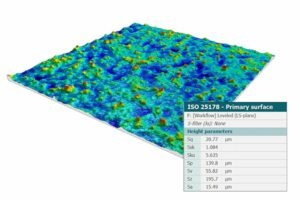
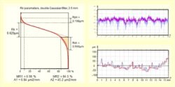
Calculate roughness and texture parameters on profiles and surfaces using ISO, ASME and VDA standards including Ra, Rq, Sa, Sq and much more.
Calculation of standardized parameters
MountainsMap® calculates roughness and texture parameters according to international standards for both 2D profiles and 3D (areal) surfaces. Supported standards include ISO 21920, ISO 4287, ISO 12085, ISO 13565, ASME B46.1, and VDA.
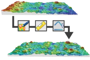
Filtering & form removal
Easily pre-process your surface data using advanced filtering and form removal tools.
Clean and correct optical measurements by removing outliers, filling missing data, thresholding low intensity points and reducing noise before analysis.
Optical measurement preparation & correction
Ensure the accuracy of optical surface measurements with MountainsMap®’s correction tools.
These preprocessing steps are essential when working with interferometric, confocal or focus variation data and help prepare your measurements for precise surface texture analysis.
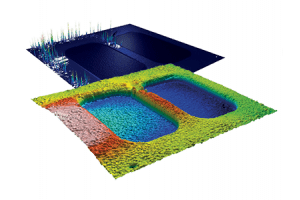
Analyze void/material volume, bearing ratio, lubrication volume and material displacement for performance-oriented surface evaluation.
Functional surface characterization
Go beyond roughness with MountainsMap®’s powerful tools for functional surface characterization.
The software also supports comparative studies (e.g., before/after treatment), making it easy to assess how surface modifications impact functional performance. These analyses help engineers design better surfaces for real-world mechanical and functional performance.
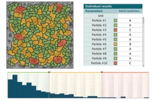
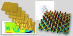
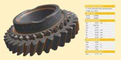
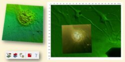
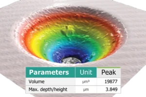
Particle analysis & deterministic surfaces
MountainsMap® detects and qualifies structures such as particles, pores, grains, scratches and MEMS patterns. Ideal for quality control in semiconductor, medical and automotive industries.
Additionally, tools for automated partitioning, surface geometry control (e.g. step heights) and structure detection enable powerful, repeatable characterization of micro-patterned surfaces or functional textures.
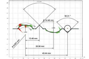
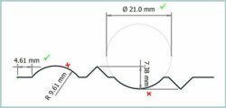
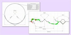
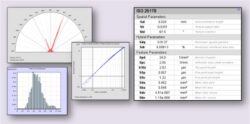
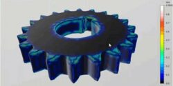
Geometric dimensioning & tolerancing - GD&T
With automatic, interactive GD&T tools, MountainsMap® enables dimensional analysis on height profiles (XZ) or 2D contours (XY) extracted from 3D surfaces. Users can ensure manufacturing precision with accurate, standard-based geometric verification.
Read more:
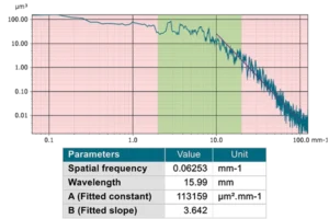
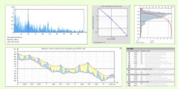
Identify periodic features and dominant frequencies using Power Spectral Density (PSD) and autocorrelation tools.
Spectral analysis
Explore the frequency content of your surfaces with MountainsMap®’s spectral analysis tools. Detect dominant spatial frequencies, analyze periodic structures and evaluate texture orientation.
Ideal for identifying process signatures, assessing performance of optics or diagnosing machining defects, spectral tools add a powerful dimension to your surface analysis workflow.
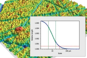
Use wavelet and bandpass filters or scale-sensitive fractal analysis (SSFA) tools to study surface behavior across multiple spatial scales.
Multi-scale surface analysis
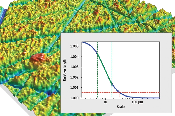
Understand the complexity of surfaces at different spatial scales with MountainsMap®’s multi-scale analysis tools.
These tools are essential for applications in functional surface design, helping engineers and researchers assess how surface properties evolve at different scales.
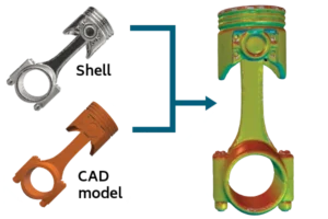
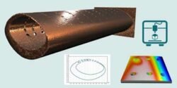
Freeform surface (shell) analysis
MountainsMap® supports the analysis of freeform surfaces – known as “shells” in the software – typically represented by triangular meshes. This is useful in applications such as additive manufacturing.
NB. Shells can be extracted from tomographic data (cubes) or obtained from multiple surface acquisitions.
Point cloud data can also be visualized and analyzed:
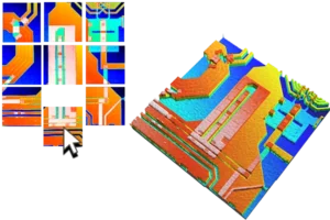
Stitch multiple surface measurements (XY or Z) or partition surfaces into elements for example in MEMS analysis.
Surface stitching & partitioning
Easily combine multiple measurements into a seamless composite with MountainsMap®’s stitching tools.


The following range of optional modules for advanced and specialized applications is available with the MountainsMap® range.
|
MountainsMap® Premium |
MountainsMap® Expert |
MountainsMap® Imaging Topography |
MountainsMap® Topography |
MountainsMap® Profile |
|---|---|---|---|---|---|
|
Instrument compatibility |
All profile and areal measuring instruments |
All profile and areal measuring instruments |
Areal optical profilers producing topography maps together with an intensity image and/or a color image
|
Areal optical or contact stylus profilometers producing topography maps
|
2D contact or optical profilometers |
Key features |
|||||
|
Profile roughness and waviness analysis |
|||||
|
Basic analysis of surface data |
|||||
|
Stitching of images and surfaces, outlier removal & multifocus reconstruction |
|||||
|
Support for file formats from optical profilers |
|||||
Optional modules |
|||||
|
Advanced profile analysis |
Option | Option | Option | ||
|
Automotive profile parameters |
Option | Option | Option | ||
|
Advanced topography analysis |
Option | Option | |||
|
Particle analysis |
Option | Option | Option | ||
|
Fiber Analysis of images & topography |
Option | Option | Option | ||
|
Contour Analysis |
Option | Option | Option | Option | |
|
Advanced Contour Analysis including CAD compare |
Option | Option | Option | Option | Option |
|
Thickness analysis |
Option | Option | Option | ||
|
4D Surface Change |
Option | Option | |||
|
Critical Dimensions & Trenches |
Option | Option | Option | ||
|
Lens Analysis |
Option | Option | Option | Option | |
|
Fourier & Wavelets Analysis |
Option | Option | Option | ||
|
Shell Extension (freeform surfaces) |
Option | Option | Option | ||
|
Shell Topography for metrological analysis |
Option | Option | Option | Option | |
|
Shell CAD compare |
Option | Option | Option | Option | |
|
Lead Analysis (Twist) |
Option | Option | Option | Option | |
|
Scale-Sensitive Fractal Analysis |
Option | Option | Option | Option | |
|
Colocalization for Correlative Analysis |
Option | Option | Option | ||


MountainsMap® is specifically designed for the analysis of surface texture on profiles and surfaces, measured with instruments measuring topography, and in some cases also producing a color image and/or an intensity image, such as:
MountainsMap® is also compatible with coordinate measuring machines (CMMs), structured light 3D systems and X-ray tomographs.
Additionally, support for a wide range of generic file formats (TXT, SDF, STL, etc.) ensures easy integration with specialized systems.
Click to see more
Digital Surf partners with many instrument manufacturers who offer MountainsMap® under their own brand, either integrated with their instruments or as an optional add-on:
Instruments from non-partner manufacturers are also fully compatible, including those from Alicona, FRT, Keyence and many others. With support for over 250 file formats, MountainsMap® covers virtually all instruments on the market, past and present. Contact us to learn more.
Retrofit of older instruments
Some older profilometers, such as those from Somicronic, UBM or Wyko, still offer solid metrological or mechanical performance but are held back by outdated software and incompatibility with modern Windows versions or current standards. By pairing them with MountainsMap®, potentially on a separate PC running Windows 10 or 11, these instruments can be upgraded and continue delivering valuable results.

Advanced Research Specialist, 3M Electronics Materials Solutions Division
I have been a Mountains® user since 1999. The technical support staff at Digital Surf have been very helpful over all these years. They have adapted the software to read custom data formats as well as provided application-specific advice on the use of some of the advanced features, such as the motifs analysis. Whenever any issues were found, Digital Surf has always responded quickly and always fixed the problem.

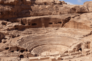
Assistant professor, University of Tusla
Mountains® software is an exceptional tool for the analysis of surface characteristics on archaeological artifacts. I use this software for the quantification of wear traces on stone tools, allowing us to identify and improve our knowledge of prehistoric human activities. The software is user-friendly and Digital Surf has excellent customer support, making Mountains® a fundamental tool for my research.