


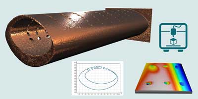
⇒ Shell data (freeform surface) management – load most types of file formats for freeform surfaces (.STL, .OBJ, .PLY, .3MF etc.)
⇒ Analyze data generated by profilers with multiple scanning axes including complex shapes (gears etc.)
⇒ Analyze objects produced by additive manufacturing
⇒ Visualize objects from all angles in high quality 3D
⇒ 3D print – produce accurate centimetric/inch-scale objects that can be manipulated from data at the sub-millimeter scale (useful for teaching purposes or prototypes)
⇒ Extract surfaces and cross-sections – extract any external or internal part of the face of an object – extract cross-sections at any angle – analyze these further using other Mountains® tools.
⇒ Extract an area of a shell and analyze it separately
⇒ Load/visualize point cloud datasets and convert them into continuous surfaces.
Included in:
- MountainsMap® Premium
- MountainsSEM® Premium
- MountainsLab® Premium
Available with:
- MountainsMap® Topography
- MountainsMap® Imaging Topography
- MountainsMap® Expert
- MountainsSEM® Expert
- MountainsSpectral® Premium
- MountainsLab® Expert