⇒ Load a series of measurements of the same surface and combine them for 4D analysis – load 3D measurements of the same surface made at different times or under different environmental conditions – combine the measurements into a series with 4 dimensions x, y, z and t, where t is time, temperature, pressure, magnetic field or another fourth dimension (linear or non-linear) – add a new measurement to the series or delete an old measurement at any time – ensure point to point matching using automatic and manual shifting tools – apply pre-processing operators simultaneously to every 3D measurement in the series.
⇒ Visualize surface, profile and point evolution – display all of the surfaces in the series in a grid or walk through them one by one – display an animated view of the surfaces as they change with respect to time or another dimension – fly over the series, see the surface changing and record a movie for presentations – extract a profile between points and see how it evolves – extract a transverse profile showing changes in the height of a single point on the surface.
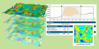
⇒ Generate statistics and highlight areas of preponderant change – generate statistics showing how one or more parameters evolve as the surface changes: parameter tables (including min, max, standard deviation), control charts, scatter plots, histograms – highlight areas of preponderant change using the Karhunen-Loève transform (principal component analysis).
⇒ Quantify wear and material deposit by comparing two successive topography measurements of the same zone – generate global parameters (projected area, volume etc.) – calculate parameters at a specific point, along a line or over a zone – define maximum and minimum limits and graphically visualize zones that are out-of-tolerance – generate stunning 3D views of wear and deposit and animate them – cross-section them to get two-profile 2D analyses with interactive measurement
Included in:
- MountainsMap® Premium
- MountainsLab® Premium
Available with:
- MountainsMap® Imaging Topography
- MountainsMap® Expert
- MountainsSPIP® Expert
- MountainsSPIP® Premium
- MountainsSEM® Expert
- MountainsSEM® Premium
- MountainsLab® Expert