With the release of version 8, the MountainsMap® product range refocuses on tools for analyzing data from 2D and 3D profilometers.* The software interface as well as many existing features have received a significant overhaul. More than ever before, this highly-specialized yet easy-to-use software is an indispensable asset for engineers, researchers and metrologists in a wide variety of sectors.
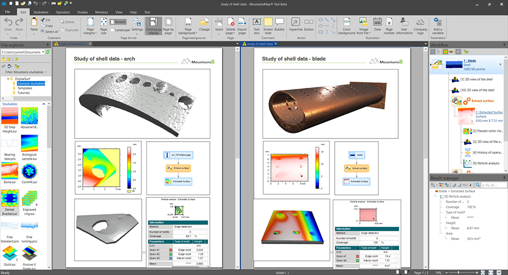
Shell data courtesy of Digisens, France & University of Huddersfield, UK
Renowned expertise in surface analysis
Digital Surf has 30 years experience developing surface imaging & metrology software for the global industrial and scientific communities. The company is an active member of the ISO working groups who establish surface texture standards. The majority of national metrology institutes (NIST in the USA, NPL in the UK, PTB in Germany, LNE in France and many others) trust the expertise and precision of Mountains®.
No one knows surface metrology like Mountains®
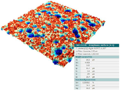
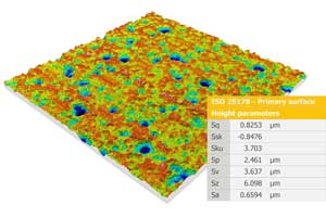
Surface metrology is an ultra-precise science where nothing is left to chance. It is also a living, evolving subject. Using Mountains® ensures you have access to the very latest ISO and national standards (our COO contributes to defining them!)
Thanks to a wealth of guides and other resources made available by Digital Surf, we aim to help users adopt relevant correction and calibration routines in order to get meaningful results from their data analysis. MountainsMap® includes processing tools for overcoming instrument restrictions (outliers, non-measured points and range limitations) thus guaranteeing you get the most out of your measured data.
Advanced tools for advanced applications
Go beyond the basics of surface texture analysis and unleash the full potential of your data.
With easy-to-use, interactive tools, carry out pore and particle analysis on structured surfaces, Fourier & wavelets analysis to study surface-process interactions or advanced contour analysis with comprehensive geometrical dimensioning and tolerancing tools.
MountainsMap® also gives users access to industry-specific analysis methods, for example 2D parameters for automotive manufacturing.
Total traceability
Thanks to the MountainsMap® workflow, more powerful than ever in version 8, keeping track of analysis steps already applied to data has never been easier. Users can instantly revert back to any step in the process, edit or delete it. As a result, all dependent steps are automatically recalculated.
Software trusted by the manufacturers
The majority of leading instrument manufacturers integrate MountainsMap® with their instruments (look for the “Powered by Mountains®” label). Today, 15,000+ Mountains® software licenses are installed worldwide.
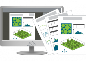
Easy publishing & report creation
As you carry out analysis on your data using MountainsMap®, the different processes are organized in document layout. This makes it easy to save your work in PDF and Word formats and thus share it with colleagues, students, clients etc. What’s more, all parameters and results can be exported to Excel at the touch of a button.
Create synergy between instruments
Using the MountainsMap® colocalization feature, data from 3D optical profilers, AFM, SEM, fluorescence, Raman, IR or other microscopes, can be managed with the same software and overlaid, thus facilitating the correlative study of features.
An international team of experts ready to assist
We believe it is our job to help our customers get the most out of MountainsMap®. Our technical support team answers your questions and offers professional advice on client applications.
To make life easier for our users, the MountainsMap® user interface is available in 11 languages, a printed reference guide is available and training and seminars can be organized on request.

Save time and gain in productivity
Working with large quantities of data? No worries. MountainsMap® can easily process it! And no need to create complicated scripts. In just a few clicks, save any analysis sequence as a template and reapply to large batches.
New features in version 8 speed things up even more by allowing you to apply operators (tools) directly as you work in the document or in the workflow.
Sounds good? Ready to try for yourself? See full features here:
MountainsMap® for Profilometry
*Similarly the MountainsSEM® product range serves the needs of Scanning Electron Microscope users and the MountainsSPIP® range those working with Scanning Probe Microscopy. MountainsLab® provides multi-instrument compatibility.