⇒ Subsurface analysis – extract a geometric subsurface (for example a component layer) from a full surface that has been partitioned using the ISO 25178 segmentation by watersheds algorithm, calculate its flatness instantaneously, analyze it in the same way as a full surface.
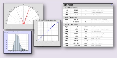
⇒ More surface texture and form parameters – ISO 25178 and EUR 15178 (Surfstand) functional volume, spatial and hybrid parameters, ISO 12781 flatness parameters
⇒ Functional volume analysis (wear and lubrication) – display ISO 25178 and Sk functional volume parameters graphically to facilitate studies on wear and lubrication – study peak/grain/particle distribution and density.
⇒ Fractal analysis – analyze the fractal dimension of a surface using the enclosing boxes and morphological envelope methods.
⇒ Surface isotropy, directionality and periodicity – calculate isotropy, periodicity, period and period direction – view dominant surface directions on a compass rose.
⇒ Map local properties – calculate parameters in a sliding window and detect areas of higher complexity or roughness within a surface.
⇒ Morphological filtering – apply morphological filters (erosion and dilation operations, opening and closing filters, sequential filters) using a plane or spherical structuring element.
⇒ MATLAB™ compatibility and math functions – load or write MATLAB™ scripts and execute them to carry out custom operations including filtering. Create algebraic operations between images/surfaces.
⇒ Study circular profiles – extract circular profiles and display the abscissa in degree units.
⇒ Analyze furrows – detect and visualize furrows above or below a threshold height – calculate furrow parameters: max depth, mean depth and mean density.
⇒ More file formats – load data produced by commercial 3D scanning profilometers, confocal, interferometers and other imaging microscopes.
Included in:
- MountainsMap® Expert
- MountainsMap® Premium
- MountainsLab® Expert
- MountainsLab® Premium
Available with:
- MountainsMap® Topography
- MountainsMap® Imaging Topography
- MountainsSEM® Expert
- MountainsSEM® Premium