⇒ Advanced 2D filtering techniques – remove form and apply roughness/waviness filters from RC2 to ISO 16610 – apply morphological filters using a straight or round structuring element – filter noisy profiles directly by editing the FFT plot within selected upper and lower bounds.
⇒ MATLAB™ compatibility – load or write MATLAB™ scripts and execute them to carry out custom operations including filtering.
⇒ Correct measurement anomalies – use data correction tools (thresholding, retouching, resampling) to eliminate anomalies and improve resolution prior to analysis.
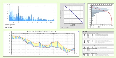
⇒ Assess surface functionality – study the bearing ratio curve and depth distribution histogram to evaluate surface functionality – subtract profiles to assess wear.
⇒ Extract sliding profiles – extract subprofiles from a long profile to check tolerances in a sliding window.
⇒ Use FFT-based tools to analyze process-surface interactions and other surface characteristics – display frequency spectrum and power spectral density plots – carry out autocorrelation and intercorrelation studies.
⇒ Fractal analysis – analyze the fractal dimension of a profile using the enclosing boxes and morphological envelope methods.
⇒ Overcome measurement limits virtually – join overlapping profiles to overcome physical measurement limits virtually, with automatic calculation of the overlap zone.
⇒ Statistical analysis of series of profiles or multiple profiles extracted from the same surface – load a series of profiles measured by 2D profilers or load surfaces measured by 3D profilers and extract one or more profiles for analysis – analyze series of profiles or multiple profiles extracted from the same surface statistically (trend plots, scatter plots, histograms) for process control or to achieve more reliable results.
Included in:
- MountainsMap® Expert
- MountainsMap® Premium
- MountainsLab® Expert
- MountainsLab® Premium
Available with:
- MountainsMap® Profile
- MountainsMap® Topography
- MountainsMap® Imaging Topography
- MountainsSEM® Expert
- MountainsSEM® Premium